I was standing on the border of Pakistan. There was desolation all around, silence in the distance, and snow falling from the sky. It was the beginning of the second week of November. It was such a white day that there was no color in the scene except my red jeep and gray jacket. The colors were covered with snow or were being covered. There was no border post, no human mark. This friendly country was the border of China. Standing on the Khanjarab Pass, my face was towards China.
The Karakoram Highway ended at the border of Pakistan. Beyond this, the highway runs through the blue waters of Lake Karakul. So one path turns to the Taklimakan Desert, the world’s second-largest dune desert.
There was a fence on the surrounding border. Suddenly, in the white scene, a herd of a few sheep came out of nowhere and, passing by me on the road, entered the borders of China and began to spread on the slopes of dry grass on the shores. Snowballs adorned the stalks of wheat-like grass-like fruit. The sheep sniffed them, nodded, and then moved on. As usual in the north, the shepherd was missing. There was no border for birds and animals, but my border was where I stood on a snowy day.

He was a scholar. I looked up at the sky, and the cotton balls came to rest on my eyelids. Then a strong wind blew, and picked me up and threw me on the shores of Lake Atabad. Lake Attaabad, which accidentally formed between the Chital, Sanglakh, and Black Mountains of the Karakoram, is one of the largest freshwater reservoirs. The water of this lake, which is 22 km long and 220 feet deep, has come to a standstill in a narrow mountain pass due to the stagnation of the Hunza River, which is formed by melting the Karakoram ice and glaciers. At the signal of strong winds blowing in the narrow pass, the green water of the lake creates waves on the surface of the water in a very attractive way.
The lake has flooded more than 18km of the Karakoram Highway, paralyzing traffic. Now the only way to cross the lake by boat is to reach the village of Husseini, where the other end of the Karakoram Highway meets the passenger.
The lake is a different kind of terror. While the lake’s waters drowned many settlements and people, trade with the brotherly country of China was severely affected. Boats now ply the lake, transporting everything from freight to humans. The lake also has its traffic. The edges are lush. The faces of the sailors are happy, and their pockets are heavy. A separate world has formed on both sides of the lake. Some are happy, and some are sad.

When the boat was full, the sailors picked up the anchor. Nothing could be heard in the engine noise. Everyone was silent in their thoughts. The water journey lasted 45 minutes. While walking, the boat took a turn from a narrow turn and saw flea cones in front. These flea mountains are pointed as if nature had planted nails in the ground.
Strong winds were blowing on the lake that day. If the boat were shaking, again and again, the heart would also start shaking. If the sailor looked at me and laughed, I would look away from him and look at the flea cones again. When the boat ran aground, everyone began to disembark. The engine stopped. The sailor came to me. The majority of the boatmen are Pakhtuns, who have come from different parts of the country to Lake Attaabad to earn a living. The sailor approached and said, “Once upon a time, we used to sail in the river Kabul. When the first shine of the sun fell on the river, we would go to work. We used to fly birds from above. Kabul is small, and time has passed. Now this mountain And their terror. ” While talking, the boat became empty. When Husseini stepped on the village’s ground, the peaks of fleas in front of him were shining in the sun.

This whole area is called Upper Hunza or Gojal. The Gojal Valley is located Pakistan, China, and Afghanistan border. Gojal’s border with China is at Khanjrab, about 15,397 feet above sea level and covered with snow year after year. To the northwest is the Chaporson area of Gojal, which borders the Wakhan region of Afghanistan. The Wakhan region is almost 6 miles wide, after which the Tajik border begins. The Karakoram Highway, which connects Pakistan with China, also passes through the Gojal Valley and enters China at Khanjrab.

Before 1974, Gojal Valley was part of Hunza State. Mir of Hunza State ruled the area. In the state of Hunza, the Gojal Valley was important in terms of defense and agriculture. Gilmat, a village in the Gojal Valley, was the summer capital of the Hunza state. The Mir of Hunza used to hold a court here, in which besides deciding cases, various issues were also discussed. Regional dance and music were also arranged at the court of the Mir of Hunza, while the famous game of polo was played in a special rectangular field in front of the palace.
Pakistan came into being in 1947, after which the Mir of Hunza, Mir Muhammad Ghazan Khan, annexed his state to Pakistan through a telegram from Gilmat. Despite the annexation, the Hunza Valley maintained its separate identity as a separate state until 1974. The political reforms of the Bhutto government resulted in the fall of the state of Hunza. Since then, the Gojal Valley has been administratively included in the Hunza sub-division of Gilgit-Baltistan as a tehsil. Locally, it is also called Upper Hunza, but the area’s official name is “Gojal.”
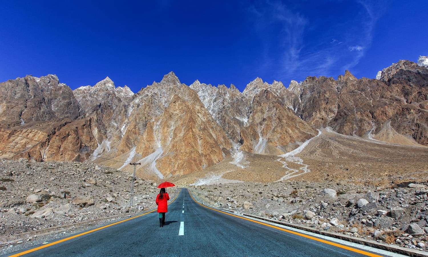
When Husseini left the village, the school children were crowded on the way. Seeing blonde hair, blue eyes, and red children reminded me of apricots. Walking along the river came Gilmat. Gilmat Valley is the most populous village of Gojal. When it was autumn, the whole village fell asleep on a mildly cold afternoon. When the wind blew, the rustling of leaves falling from the trees would break the silence.
The flea cones were equally insightful. The fields were empty. With the onset of winter, farmers were probably resting at home after work. A few older women were seen wearing traditional hats on their heads, behind which small wicked children were laughing and joking. He greeted me as I passed by and received many prayers in reply. The children’s laughter echoed in the valley for a long time. As the jeep drove away, I saw in the mirror that the children left behind were waving goodbye. Now there was seriousness on their faces.

A little further on, a dirt road turns to Lake Burt. After only a kilometer, the lake is visible. There is an old hotel on the shore, the food of which I still do not forget. Long grass grew on the shores of the lake. In the backdrop stood snow-capped mountains, reflected in the muddy waters. Four ducks were floating on the surface of the water.
The color of this lake is black, so it may be a pleasure to see ducks on such deep black waters, but according to Tarar, “What does happiness have to do with four ducks?” Happiness is related to the inside of a person. As I walked around the lake, the scenery changed step by step. The lake was home to aquatic life and migratory birds at one time, but now the water level is receding, and the lake is drying up over time.
A flock of four ducks flew and headed for the distant snow-capped mountains. Happiness departed with their flight. She was hungry until she got back to the hotel. The old man greeted me warmly and said, “After being affected by tourism because of the situation, now and then I get lost here, so I also manage to spend time. You have to take good pictures of this lake.” “And to show the world that tourism can flourish again and my children’s livelihood is at stake, I feed you delicious food.” The older man’s bribe brought moisture to his eyes and a smile to his lips.
A Danish girl came to visit. When the conversation started, she learned that she is a Ph.D. student and is writing a dissertation on climate change in the Karakoram Range in Pakistan. She said that she had been on Bort Lake for three months. I loved this place and the lake so much that I didn’t feel like going back yet, and here I am living in a room. Then he said, “Have you seen this lake on a full moon night? If not, stop here and see it tonight. I’m sure you won’t find such a picture again.”
She was walking away as she spoke. Maybe three months he had to speak together. The jeep driver and I ate and listened to him. When he started walking, he said, “Your country is beautiful. If you go to Paso village, you must go to Batura Glacier. I have seen white swans descending on the white snow there.” I nodded and walked away.

The driver asked in astonishment as he walked, “Mr. Glacier, every swan descends. We have never seen it. Our childhood has passed here.” I said to the driver, “She was a madman, and in the madness of the madmen, she laughed at the glacier. Pigeons could land, and butterflies too. I also saw caravans of jaguars on the river Chenab.” The driver started smiling and came to the village with a smile.
It was getting dark when the jeep entered the village of Pasu. The peaks were going to be like copper. Before the last hiccups of the sun took place, the night began to spread in the Flea. I checked in at the hotel and lay down in the room to rest. When he came out after a while, the stars in the sky were on the earth. There were lights outside, places of worship were abuzz, and children, the elderly, girls, women all walked to the synagogue. It was the birthday of a spiritual leader. The night was bright. People were out of their homes. It was cold and shimmering. The sky was bright with stars. The full moon rested on a mountain. A Danish girl may have had a stroke on the shores of Lake Burt.
There were glittering clothes in the morning scene. It was the time of Eid. There was joy on their faces. I had toys in my hands. There were prayers on the lips of the elders. It was just like Eid-ul-Fitr. Flea autumn was a beautiful morning. The people were beautiful. My camera was locked in my bag. You should avoid taking pictures at local festivals and especially religious festivals because you are a stranger to these people. People are happy to perform their religious rites to their tune, so what is the need for anyone? To object?
Beauty descended from the sky and entered the valley and the people living in the valley. This morning, traveling on the Karakoram Highway, every town, every alley, every village saw prosperity. Leaving Flea and heading towards Sost, a Jeep Road turns towards Shimshal.
Shimshal Valley is a vast area bordering China and Baltistan. The Shimshal Valley also includes the Pamir region. Shimshal was cut off from the rest of the world due to its location in a rugged valley but eventually became a jeep road to this beautiful valley and the land of tough climbers. Local craftsmen and hard workers have made significant sacrifices in the construction of the road. One of the main reasons for Shamshal’s fame is the young mountaineer Samina Baig, who was born here, who became the first Pakistani woman to climb the world’s highest peak. Apart from them, mountaineers Rajab Shah and Mehraban Shah from Shimshal Valley can climb the highest peak in Pakistan. A large number of eminent and experienced mountaineers belong to Shimshal.

Slow down, A town full of jeeps, trucks, wagons, and workshops. Sost is also called the last town of Pakistan because there are no villages or human populations beyond Sost on the Karakoram Highway towards China. After Sust, the Khanjarab Pass is located at an altitude of 15,397 feet, where the borders of Pakistan and China meet. In addition to the Pakistan Customs offices in Soost, there is also a dry port, where goods coming and going from China to China are kept safe.
Many traders and laborers from different parts of Pakistan also reside here, due to which the economic activities here are higher than in other regions. Going further from Sost, another Jeep Road leads to Chaporson Valley. The Chaporson Valley consists of a long ravine, the northwestern end of which is connected to the Wakhan region of Afghanistan by the Yershod Pass.
Khanjrab is Pakistan’s last stop on the Karakoram Highway beyond Sost. The dwarf is a compound word in the local language, “Khun” meaning blood and “giraffe” meaning glacial river, meaning “river of blood.” It is said that an ancient priest said of this valley that a great battle would be fought here and that there would be so much bloodshed that the cavalry would sink into it. Due to this, the area was named Khanjraf, meaning “river of blood.” Due to their unfamiliarity with the local language, non-natives named the area “Khanjarab” instead of “Khanjaraf.” The area is rich in natural resources and is home to some of the rarest animals, the snow leopard, the polar bear, and the golden eagle.
Arrived in Khanjarab at the beginning of the second week of November, greeted by snow. The snow was constantly whitewashing mountains, paths, rocks, and canals. Standing somewhere between Pakistan- China border, I raised my face to the sky, and snowballs began to fall on my eyelids. By the time I lost consciousness, my face was frozen. The ice cubes were turning into the water with the heat of the breath. There was a burden on the eyelids. After wiping his face with a handkerchief, the driver said, “Sir! Pakistan is over here. Let’s go back home?” When the driver turned the car, I sat on the seat and said, “Sharif! Pakistan starts from here.” On a signboard on the right was written: “Welcome to Pakistan.”
Comment (0)